Perspective Views and Topographic Mapping of Icy Moons and Dwarf Planets - (with a nod to "SCTV")
12 January 2011
Mimas Picture Show
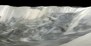
At last I have my hands on the February 2010 Mimas encounter data (I am not on the project so I have to wait 12 months to use it . . . ). The encounter produced several mosaics which allow us to produce detailed topographic and color maps of the surface centered on the great 130-km-wide Herschel impact basin. I will be writing a detailed report on this relatively young giant crater later, but in the meantime here are some cool views of the interior of the crater and its surroundings. It is shaped like a big 12-kilometer-deep cereal bowl with a large 5-kilometer-high mound in the middle. One can also see a little bit of icy debris slumped along the base of the inside rim scarp, which rises 2 kilometers above the surrounding plains (1 kilometer = 0.6 miles). (A preliminary profile based on earlier data was presented in my post in February last year.) A note bout the views, my current 3d renderer assumes the terrain is flat and so we don't yet see the curvature of Mimas, which would be very pronounced in a normal view. I'm working on implementing a new renderer soon.
Subscribe to:
Posts (Atom)


